www.lovemeow.com
Blind Kitten, Once Lost Outside, Now Melts Every Heart He Touches and Grows So Close to a Cat
A blind kitten, once lost outside, now melts every heart he touches and has grown incredibly close to another cat.
FlannelBetsy @betsyherrelkoDespite having used several of his nine lives, Flannel, the kitten, never let anything hold him back and continued to love every person he met.He was found wandering alone, unable to see due to a severe upper respiratory infection. When a Tails High volunteer learned that he urgently needed rescue placement, she leaped into action.Within days of being in foster care, Flannel blossomed into the ultimate love bug. "From the moment he was rescued, he was rubbing all over his foster mom and giving her kisses and head boops," the rescue shared.
Tails HighFlannel made himself right at home, crawling onto people's laps and showering them with endless affection. "He had clearly been through so much, but he purred through it all.""While we don't know how Flannel ended up outside, fending for himself when he was so sick and unable to see, we do know he had to have known human touch and companionship at some point in time."
Tails HighWithout sight, Flannel expertly mapped out his surroundings. He confidently navigated the house, climbed stairs, and used the litter box with ease.After his eye surgery, Flannel felt much better, bouncing around with renewed energy. "He has never slowed down one bit, despite having such a hard start to life and going through so much strife before being rescued."
Tails HighFlannel was incredibly friendly with other kitties, letting them pounce on his head during play and cuddling with them when they napped. "He is a sweet pea to every human and kitty he meets, wanting nothing more than love."He stole the show at every meet-and-greet, nestling into potential adopters' laps and showing off his high jumps. Despite being blind, he never missed a step.
Betsy @betsyherrelkoThat's when he caught the eye of Betsy and quickly had her wrapped around his little paw."She described the type of kitty she was looking for, explained the broken heart she was nursing back to life after losing her most special senior kitty, and we just had a feeling... Flannel was her boy."
Flannel cuddled with his forever momBetsy @betsyherrelkoFlannel strutted around his new home, full of unbridled energy. Soon, he was zooming around, jumping and scaling tall furniture like a ninja.His fearless attitude and curiosity make him an excellent companion and travel buddy.
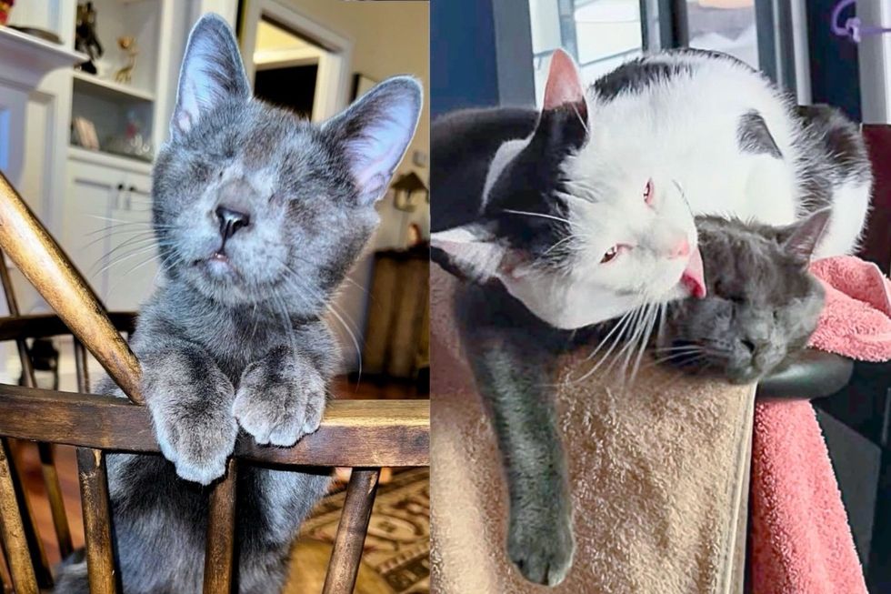
Flannel loves playing fetchBetsy @betsyherrelko"He is living his best life, greeting the residents of his building in the lobby, distracting mom from work, and taking in the smells of the city from his favorite window perch."Flannel had always wanted a constant friend, and when Betsy brought home a new feline brother, Abba, he was instantly smitten.
Abba and FlannelBetsy @betsyherrelkoAbba was very shy at first with all the unfamiliar sights and sounds and took refuge behind the couch. With a good TV program and plenty of patience, he slowly came out of his shell. But the true magic happened when he met Flannel.Perhaps Flannel's confidence and friendliness eased his worries and gave him the courage he didn't know he had.
They became fast friendsBetsy @betsyherrelkoAfter a proper sniff greeting, they became fast friends. They began zipping around the house, sharing toys and adventures. When worn out from a whirlwind of play, they curled up side by side and fell asleep to the sound of their harmonized purrs.Flannel melts as Abba wraps around him and washes his face.
Betsy @betsyherrelkoAbba adores his little brother, who is completely obsessed with him. They are joined at the hip and spend every moment together."Flannel's fairy tale is one that inspires us to keep fighting for the underdog... well, undercat."
Best of friendsBetsy @betsyherrelkoShare this story with your friends. More from Tails High on Instagram and Facebook. Thanks to Betsy @betsyherrelko.Related story: Cat Shows Up at a House Looking for Food, They Realize She's Deaf with a Heart of Gold